Greater Manchester set to be hit by snow, ice and wind
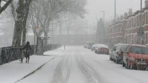
Manchester: It’s hard to believe that just a fortnight ago the country was basking in 20c sunshine – now Greater Manchester is set to be hit by snow, ice and wind.
Yellow weather warnings have been put in place for the region, with the cold and blustery weather expected to last well into next week.
Snow has – and continues to fall – in some places, with temperatures continuing to plummet.
The Met Office snow warning is due to run until late Sunday morning, with the snow and ice warning in place from 9pm that evening.
Forecasters say it could cause problems on the roads early on Monday – so we can expect to see the gritters out and about.
They said: “Widespread icy patches will develop on untreated surfaces Sunday evening and night.
“Wintry showers will also continue through Sunday evening and night onwards into Monday morning, especially over Scotland and Northern Ireland.
“Snow accumulations will tend to be largely confined to hills and mountains above 200-300 metres where a few cms snow is possible.
“At lower-levels, any accumulations of snow will tend to be quite small and patchy in nature with most areas not seeing any snow settling.”
A yellow wind warning is in place from just after midnight until 3pm that day, with travel delays and power cuts likely.
The Met Office added: “A spell of strong northwesterly winds across Northern Ireland is expected to extend across much of England and Wales through Wednesday.
“Gusts of up to 50-55 mph are likely inland and 65 mph along western coasts. Winds will gradually ease during the afternoon.”