Storm Floris to bring ‘unseasonably disruptive’ rain and wind to UK
London: Storm Floris has been named by the Met Office and will hit the UK on Monday, bringing strong winds and heavy rain.
It is the sixth named storm this season and the first since January.
Current forecasts show the centre of Floris travelling across the northern half of the UK, with the strongest and most disruptive winds on the southern and western edge of the area of low pressure.
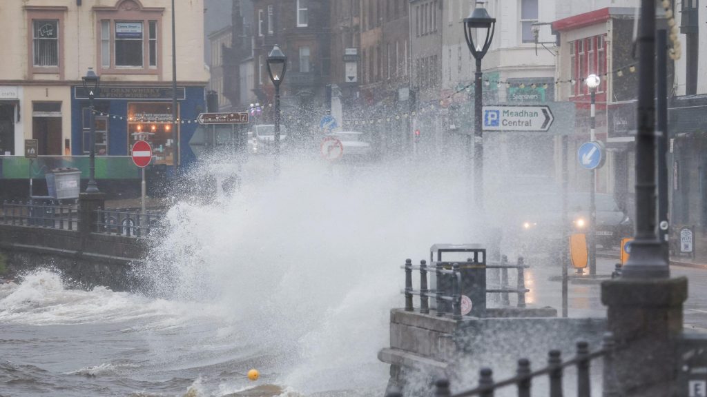
Storm Floris will bring strong winds and heavy rain across the UK on Monday with the worst of the weather for northern coasts
Some forecasts show the potential for wind gusts of between 60 and 70mph in places, particularly for coasts and hills in the north during the day on Monday. Exposed coastal areas of Scotland could see gusts of up to 85mph.
Across the warning area, many inland areas are likely to see gusts of 40-50mph.
Even for areas in the south there could be gusts of 40-45mph.
The area of cloud and rain that may bring some of us the stormier spell was still only a band of heavy showers near the Great Lakes in the US on Thursday morning.
As this heads out into the Atlantic it will get picked up by an active jet stream and will develop into a storm with a huge drop in pressure as it nears our shores.
It is worth noting that Monday is still a number of days away and the exact track of the low pressure system will be crucial to which areas may be worst affected and so it is worth staying across the BBC Weather forecast over the coming days to keep across the latest.
If the winds do reach their forecast strength then they are likely to have an impact on travel.
At this time of year trees are in full leaf and are more likely to be toppled with branches broken off than during the winter when the wind can whistle through them unimpeded.
Many temporary summer structures including tents could be damaged.
Power disruption and some damage could also be possible while heavy rain and flooding could be an additional hazard in places.
Storms are named by the Met Office and by the Dutch and Irish water service equivalents when they are judged to have the potential to cause disruption or damage.
A low pressure system like Floris would not be that unusual during the autumn or winter months but it will have greater impacts during summer.
But named storms in August are not that rare.
Last year, Storm Lilian struck the UK on 23 August just before the bank holiday weekend, closing stages at the Leeds Festival and cancelling Heathrow flights.
In 2023, Storm Antoni brought wet and very windy weather to south Wales and south-west England affecting events such as Brighton and Plymouth Pride. Less than two weeks later Storm Betty brought further disruption.
In 2020 there were also two August storms – Ellen and Francis – that the Met Office describes as “two of the most notable August storms in the last 50 years.”
These two storms brought wind gusts of 79mph and 81mph respectively with transport disruption, coastal flooding and power cuts.
Last month was the UK’s fifth warmest July on record, according to provisional figures from the Met Office.
All four UK nations recorded one of their top 10 warmest Julys: Scotland and Northern Ireland saw their sixth warmest, England its seventh and Wales its tenth.
July was the sixth consecutive month of above-average mean temperatures for the UK, the Met Office said.
The first day of the month brought the highest temperature of the year so far, with 35.8C in Faversham, Kent.
Rainfall amounts were slightly below average but there were stark regional differences.
While Kent had a very wet July, with 86% more rain than the long-term average, Dorset saw just under half of its typical rainfall for the month.
A significant marine heatwave around the UK continues with sea surface temperatures 1.5-2C above the seasonal average.
As our climate continues to warm we can expect to see milder, wetter winters and hotter, drier summers become more normal.