Strong winds and heavy rain forecast as stormy weather to hit the UK
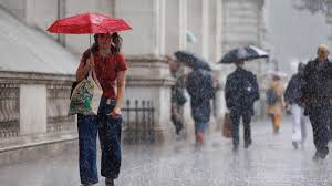
London: Low pressure is sweeping in from the Atlantic bringing a spell of strong winds and heavy rain across the UK.
A Met Office Yellow wind warning has been issued across most of England and all of Wales and is valid from 20:00 BST Sunday until 18:00 BST Monday.
Coastal gales may develop bringing large waves to southern and western shores.
Travel disruption and power cuts are also possible.
Sunday started dry for most but heavy outbreaks of rain will spread in from the west during the day, reaching eastern England and central Scotland by the late afternoon. Winds will strengthen too, especially for south-west England where coastal gales are likely to develop.
Throughout Sunday night and into Monday gusts up to 45-55mph are expected inland with 60-70mph possible around coasts and hills. Whilst these wind speeds are fairly typical for an autumn storm like this, trees are still in full leaf, which may increase the chance of branches or small trees coming down.
Heavy rain is an additional hazard with 10-30mm falling widely, with some western hills having around 70mm.
The Met Office says it is currently “not expecting to name the storm”. The warning level for the UK is only yellow, which is the lowest tier.
However, storms are named in association with Ireland’s Met Éireann and the Netherlands’ KNMI, so if the forecast changes in any of these regions, there is a small potential for one of these agencies to name it.
A storm is named when it is forecast to cause “medium” or “high” impacts. The first name in in this season’s storm list would be ‘Amy’.
As we transition from summer to autumn, we typically see the jet stream moving further south and strengthening in September, which gives rise to more unsettled, stormy weather to move in from the Atlantic.
So far this September we’ve already seen more than the expected rainfall for the whole month for several parts of the UK.
As we head deeper into the autumn months most forecast models indicate an increased chance of a ‘wetter than average’ spell until November in the UK.
However, there is always a lot of uncertainty in seasonal forecasts, and these should be interpreted as likely trends rather than expected conditions.
It’s unlikely we’ll see a repeat of September 2024 which was the wettest on record for 10 English counties, including Bedfordshire, Buckinghamshire and Wiltshire. They received more than three times their expected September rainfall leading to widespread flooding.